- Technology
- 1 Comment
How NTRIP Revolutionizes Real-Time GNSS Positioning

Introduction
In the realm of precision agriculture, NTRIP (Networked Transport of RTCM via Internet Protocol) stands as a beacon of innovation. This groundbreaking technology has revolutionized the way farmers and agronomists approach farming. In this article, we will delve into the world of Networked Transport of RTCM via Internet Protocol, exploring its myriad applications, and benefits, and answering frequently asked questions. Join us on this journey to uncover how it can change the face of modern communication.
Overview
It is a revolutionary technology that has transformed precision agriculture. This technology enables real-time communication between GPS receivers and reference stations through the internet, providing highly accurate corrections for GPS data.
The Birth of NTRIP:
It was born out of the need for precise GPS data in agriculture. Farmers and agronomists required accurate positioning information for tasks such as planting, harvesting, and soil sampling. Traditional GPS systems fell short of providing the level of accuracy needed, which led to the development of this protocol.
How it Works:
At its core, it works by transmitting differential correction data from reference stations to GPS receivers in the field through the internet. These corrections enhance the accuracy of GPS coordinates, ensuring that agricultural machinery and equipment operate with precision.
Advantages:
- Unparalleled Accuracy: It offers centimeter-level accuracy, ensuring precise field operations.
- Real-time Data: Farmers receive real-time correction data, optimizing decision-making.
- Cost-Efficiency: Reduced input wastage and improved yields make it a cost-effective solution.
How NTRIP can transfer data from sender to receiver?
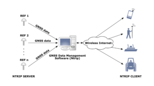
Users commonly employ this protocol to transfer real-time GNSS (Global Navigation Satellite System) correction data from a sender (usually a reference station or a correction service provider) to a receiver (typically a GNSS rover or a user device) over the Internet. It finds common use in applications demanding precise positioning and navigation, such as in agriculture, surveying, and construction.
Here’s how NTRIP transfers data from sender to receiver:
- Data Generation: The process starts with the generation of correction data by a reference station or a GNSS correction service provider. This data typically includes corrections for satellite clock errors, satellite ephemeris data, ionospheric and tropospheric corrections, and other factors that can affect the accuracy of GNSS signals.
- Data Format: Usually, the correction data is formatted in the RTCM (Radio Technical Commission for Maritime Services) standard. RTCM is a protocol that defines the format for transmitting GNSS correction data.
- NTRIP Caster: The correction data is then sent to a Caster. A Caster is a server that collects correction data from multiple sources (reference stations) and makes it available to users (receivers) over the Internet. The Caster is responsible for managing and distributing the data streams.
- NTRIP Server: The Caster communicates with a Server, which is responsible for handling client requests and managing the data streams. The Server typically requires authentication to ensure that only authorized users can access the correction data.
- NTRIP Client (Receiver): On the receiver side, there is a Client (often integrated into GNSS receivers or user devices). The Client connects to the Server using a TCP/IP connection over the Internet. It sends a request specifying the desired correction data stream, usually identified by a specific mount point or stream identifier.
- Data Streaming: Once the Client connects and authorizes, the Server starts streaming the correction data in real time to the client. It transmits the data using the RTCM format.
- Correction Data Application: The Client receives the correction data and applies it to the GNSS observations it receives from satellites. By applying these corrections, the receiver can improve the accuracy of its position calculations, allowing for centimeter-level or even sub-centimeter-level accuracy in real-time positioning.
- Position Calculation: With the corrected GNSS data, the receiver can calculate its precise position in real time, taking into account the corrections for various errors and biases.
- User Application: The precise positioning information can be used in various applications, such as agriculture, surveying, navigation, or any other field that requires accurate location information.
It is an essential technology for achieving high-precision GNSS positioning in real-time over large geographic areas. It enables users to access correction data from remote reference stations and apply these corrections to their GNSS measurements, significantly improving the accuracy of their position solutions.
How They Communicate:
- The Caster collects correction data from various sources, usually GNSS base stations with precise positioning data.
- The Server connects to the caster and receives this data.
- The Client (PolaRx5) connects to the server and requests correction data through a specific mount point.
- The server then streams the correction data to the client in real time, which is used to enhance the accuracy of the PolaRx5’s GNSS positioning.
For more information related to setup/configuration please read: How to set up an internal NTRIP caster on a Septentrio Receiver
Real Applications:
It found applications across various facets of precision agriculture, enhancing efficiency and productivity.
Precision Planting:
In precision planting, accurate row spacing and seed placement are essential. It ensures that each seed is planted with utmost precision, leading to uniform crop emergence and higher yields.
Soil Sampling:
For soil sampling, It provides accurate georeferencing, allowing for precise sample collection at specific locations within a field. This data aids in soil fertility analysis and tailored nutrient application.
Harvesting Efficiency:
During harvesting, It enables automated steering systems to maintain precise row spacing, minimizing crop damage and increasing harvesting efficiency.
Irrigation Management:
Efficient water use is crucial in agriculture. It helps optimize irrigation by ensuring precise equipment navigation and water distribution.
FAQs
Let’s address some common questions about it:
Q: What is the significance of it in precision agriculture?
This significantly improves the accuracy of GPS data used in precision agriculture, leading to better crop yields and reduced input wastage.
Q: Can it be used with existing GPS equipment?
Yes, It is compatible with most modern GPS receivers, making it accessible to farmers with existing equipment.
Q: How reliable is it in the areas with poor internet connectivity?
The designers have designed the systems to handle intermittent internet connectivity, ensuring that data transmission is as stable as possible.
Q: Does it require a subscription?
Yes, these services often require a subscription, but the benefits in terms of improved yields and reduced costs justify the investment.
Q: Are there any privacy concerns?
Primarily focuses on transmitting correction data, and the information it uses is not typically sensitive or private.
Q: Can it be used in small-scale farming?
It can be beneficial for small-scale farming operations, especially when precision is crucial for crop success.
Read More: How AI Applications are Transforming Industries
Conclusion:
In the ever-evolving world of agriculture, precision is key. NTRIP has emerged as a game-changer, offering farmers and agronomists the accuracy and efficiency they need to thrive in today’s competitive environment. Its applications are incredibly diverse; furthermore, its benefits are substantial, and undoubtedly, its future is bright. Embrace the NTRIP revolution, and watch your fields flourish.
1 Comments
[…] Read More: How NTRIP Revolutionizes Real-Time GNSS Positioning […]